Wednesday, November 28, 2018
Saturday, October 13, 2018
Sunion
Between myth and history
There are stories about the ship of King Menelaus who stopped briefly at Sounio on his way back from Troy; or about the unfortunate King Aegeus who drowned himself on that spot and the Aegean Sea got named after him; or about the people who built a temple using local marble to honour the god of the sea and safeguard the profits from the neighbouring Lavrio mines.
Notice the Doric columns, count their flutes and you will see that they are less in number than those on other temples of the same period (mid 5th c. BC). This feature is also found in other seaside ancient temples, for instance in the Temple of Aphaea in Aegina etc.
How to get there
Sounio is located on the southernmost tip of Attica; it is the end point of the Athenian Riviera, at a 69km distance from Athens. Take the intercity coach (KTEL) from Aigyptou Sq. (Victoria ISAP Station) or travel by car along the coast of Athens and Attica (passing by Glyfada, Vouliagmeni, Varkiza, Lagonisi, Anavyssos, Legrena and so on). You will be impressed by the lovely view of the sea and of the Saronic Gulf Islands.
Archaeological evidence indicates that Sounion was a sacred area as far back as the Bronze Age, but the temple visible in our day was built in the middle of the 5th century BCE (between 444 and 440 BCE). It was part of the ambitious building project initiated by Perikles, which included other renown temples such as the Parthenon and the Hephaisteion. Given the similariteis of the Temple of Poseidon to the Hephaisteion and the temple of Nemesis in Rhamnous, many historians have concluded that they were designed by the same architect. One particularly unifying feature of all three temples is the fact that the columns of the porch were aligned with the third column of the peristyle.
An inscription confirms that the temple was dedicated to Poseidon, and it was built upon the remains of an even earlier poros temple whose foundations are still visible. This Archaic temple was razed by the Persians in 490 BCE when it still under construction. Very little is known about this earlier temple, but it is certain that it was a revered landmark, visible from afar as sailors approached or left the safety of the Attica harbors. The newer temple closely follows the size and plan of the more ancient one.
The temple of Poseidon was a peripteral building of the Doric order, made of marble from nearby Agrileza, with six columns at its ends and thirteen on each long side for a total of 34--of which thirteen survive today. Four of the north columns were reconstructed in the late 1950's. The Doric colums are about 20 feet tall and three feet in diameter, with the unusual number of 16 flutes instead of the usual 20. The base of the temple consists of two stacked terraces that supported the peristyle, the cella, the pronaos, and the opisthodromos. The temple's stylobate is 31.1 x 13.4 meters.
The temple's metopes were smooth with no decoration, but the architrave of the pronaos was decorated with a shallow Ionic continous frieze. The frieze's fragments that have survived are baddly erroded but it is believed they illustrated popular mythological themes of amazonomachy (or a battle between Centaurs and Lapiths), gigantomachy, and the deeds of Theseus. They were carved in white marble from Paros. The pediments' raking cornice had a pitch of 12.5° (instead of the usual 15°) and were decorate with sculptures, of which only one fragmented seated female figure has survived.
Cape Sounion (Modern Greek: Aκρωτήριο Σούνιο Akrotírio Soúnio [akroˈtirʝo ˈsuɲo]; Ancient Greek: Ἄκρον Σούνιον Άkron Soúnion, latinized Sunium; Venetian: Capo Colonne "Cape of Columns") is the promontory at the southernmost tip of the Attic peninsula, 8 kilometres (5.0 mi) south of the town of Lavrio (ancient Thoricus), and 70 kilometres (43 mi) southeast of Athens. It is part of Lavreotiki municipality, East Attica, Greece.
Cape Sounion is noted for its Temple of Poseidon, one of the major monuments of the Golden Age of Athens. Its remains are perched on the headland, surrounded on three sides by the sea.
Archaeological finds on the site date from as early as 700 BC. Herodotus (VI.87) mentions that in sixth century BC, the Athenians celebrated a quinquennial festival at Sounion, which involved Athens' leaders sailing to the cape in a sacred boat.
The deme was located between Amphitrope to the west and Thorikos to the north. Its territory included parts of the Mines of Laurion. According to Traill (1986), the center of the settlement was situated somewhat to the north of the cape, between the modern settlements of Ano Sounio and Kato Sounio (close to 37.674°N 24.030°E).[3]
Sounion was fortified in the nineteenth year of the Peloponnesian War (413 BCE) for the purpose of protecting the passage of the cornships to Athens,[4] and was regarded from that time as one of the principal fortreses of Attica.[5] Its proximity to the silver mines of Laurium probably contributed to its prosperity, which passed into a proverb;[6] but even in the time of Cicero it had sunk into decay.[7] The circuit of the walls may still be traced, except where the precipitous nature of the rocks afforded a natural defence. The walls which are fortified with square towers, are of the most regular Hellenic masonry, and enclose a space or a little more than half a mile in circumference. The southern part of Attica, extending northwards from the promontory of Sounion as far as Thoricus on the east, and Anaphlystus on the west, is called by Herodotus the Suniac angle (τὸν γουνὸν τὸν Σουνιακόν).[8] Though Sounion was especially sacred to Athena, we learn from Aristophanes that Poseidon was also worshipped there.[9]
 The temple of Poseidon at Sounion was constructed in 444–440 BC. This was during the ascendancy of the Athenian statesman Pericles, who also rebuilt the Parthenon in Athens.
It was built on the ruins of a temple dating from the Archaic period.
It is perched above the sea at a height of almost 60 metres (200 ft). The design of the temple is a typical hexastyle, i.e., it had a front portico with six columns.[12]
Only some columns of the Sounion temple stand today, but when intact it
would have closely resembled the contemporary and well-preserved Temple of Hephaestus beneath the Acropolis, which may have been designed by the same architect.
The temple of Poseidon at Sounion was constructed in 444–440 BC. This was during the ascendancy of the Athenian statesman Pericles, who also rebuilt the Parthenon in Athens.
It was built on the ruins of a temple dating from the Archaic period.
It is perched above the sea at a height of almost 60 metres (200 ft). The design of the temple is a typical hexastyle, i.e., it had a front portico with six columns.[12]
Only some columns of the Sounion temple stand today, but when intact it
would have closely resembled the contemporary and well-preserved Temple of Hephaestus beneath the Acropolis, which may have been designed by the same architect.
As with all Greek temples, the Poseidon building was rectangular, with a colonnade on all four sides. The total number of original columns was 36: 15 columns still stand today. The columns are of the Doric Order. They were made of locally quarried white marble. They were 6.10 m (20 ft) high, with a diameter of 1 m (3.1 ft) at the base and 79 cm (31 inches) at the top.[13] At the center of the temple, colonnade would have been the hall of worship (naos), a windowless rectangular room, similar to the partly intact hall at the Temple of Hephaestus. It would have contained, at one end facing the entrance, the cult image, a colossal, ceiling-height (6 metres (20 ft)) bronze statue of Poseidon.[14]
 The temple of Athena Sounias (Ναός της Αθηνάς Σουνιάδος 37.653°N 024.027°E),
some 300 m northeast of the temple of Poseidon,
is built on a low hill. It was built in 470 BC, replacing an older
building of the 6th century.
Its architecture was unusual inasmuch as it had a colonnades on the
southern and eastern, but not on the western or northern sides, a
peculiarity mentioned by Vitruvius.[15] It was built adjacent to a peribolos identified as the burial mound and shrine to Phrontis, the helmsman of Menelaus whose burial at Sounion is mentioned in the Odyssey.
The temple of Athena Sounias (Ναός της Αθηνάς Σουνιάδος 37.653°N 024.027°E),
some 300 m northeast of the temple of Poseidon,
is built on a low hill. It was built in 470 BC, replacing an older
building of the 6th century.
Its architecture was unusual inasmuch as it had a colonnades on the
southern and eastern, but not on the western or northern sides, a
peculiarity mentioned by Vitruvius.[15] It was built adjacent to a peribolos identified as the burial mound and shrine to Phrontis, the helmsman of Menelaus whose burial at Sounion is mentioned in the Odyssey.
A smaller Doric temple next to the temple of Athena is thought to have been dedicated either to the hero Phrontis or to Artemis.[16] A deep pit to the southeast of the temenos was used to deposit the remains of the Archaic-period offerings destroyed in the Persian invasion.
The temple of Athena was demolished in the 1st century AD, and parts of its columns were taken to Athens to be used in the South-East temple of the Agora.[17]
 In 413 BC, during the Peloponnesian War against the Spartans,
the Athenians fortified the site with a wall and towers to prevent it
from falling into Spartan hands. This would have threatened Athens'
seaborne grain supply route from Euboea.
Athens' supply situation had become critical since the city's land supply lines had been cut by the Spartan fortification of Dekeleia, in north Attica.[18]
The Sounion fortress was soon later seized from the Athenians by a force of rebel slaves from the nearby silver mines of Laurium.[19]
In 413 BC, during the Peloponnesian War against the Spartans,
the Athenians fortified the site with a wall and towers to prevent it
from falling into Spartan hands. This would have threatened Athens'
seaborne grain supply route from Euboea.
Athens' supply situation had become critical since the city's land supply lines had been cut by the Spartan fortification of Dekeleia, in north Attica.[18]
The Sounion fortress was soon later seized from the Athenians by a force of rebel slaves from the nearby silver mines of Laurium.[19]
The Temple of Poseidon was situated in the southeastern corner of the fortress, with the garrison quarters arranged along a main stream on the western slope of the hill. The fortress included a small naval base, with a shipshed for two warships in the northwestern corner (37.6524°N 24.0228°E).[20] The fortress was maintained well into the Hellenistic period.[21] Repairs and additions to the fortress were made during the Chremonidean War (266–261 BC).
 The name Capo Colonne (graecicized Καβοκολώνες Kavokolones)
is reported from the 17th century, for the reason that unusually,
several columns of the temple of Poseidon had remained standing since
antiquity.
Early modern descriptions in travelogues include those by G. Wheler (1676), J.-D. Le Roy (1754), R. Chandler (1765) and E. Dodwell (1805).
Scottish poet William Falconer
(1732-1769) was shipwrecked off off Cape Colonna, as Sounion was then
known, in 1750, an event depicted in the central scene of his The Shipwreck (1762).[22]
The name Capo Colonne (graecicized Καβοκολώνες Kavokolones)
is reported from the 17th century, for the reason that unusually,
several columns of the temple of Poseidon had remained standing since
antiquity.
Early modern descriptions in travelogues include those by G. Wheler (1676), J.-D. Le Roy (1754), R. Chandler (1765) and E. Dodwell (1805).
Scottish poet William Falconer
(1732-1769) was shipwrecked off off Cape Colonna, as Sounion was then
known, in 1750, an event depicted in the central scene of his The Shipwreck (1762).[22]
The inscribed name of George Lord Byron, carved into the base of one of the columns of the Temple of Poseidon, possibly dates from his first visit to Greece, on his Grand Tour of Europe before he acquired fame. Byron spent several months in 1810–11 in Athens, including two documented visits to Sounion. There is, however, no direct evidence that the inscription was made by Byron himself. Byron mentions Sounion in his poem Isles of Greece:
 Cape Sounino a popular day-excursion for tourists from Athens, with the sunset over the Aegean Sea, as viewed from the ruins, a sought-after sight since the first development of modern tourism in the early 19th century.[25]
Lavreotiki municipality was established in 1890 under the name of Sounio, but renamed to Lavreotiki in 1891. Cape Sounion itself is located between the villages of Kato Sounio and Legena.
The Sounio national park (Εθνικός Δρυμός τού Σουνίου) was established in 1974 with a core area of 750 hectares.
Forming the southeastern endpoint of the Athens Riviera, Sounio is now an upscale summer home location for Athenians. Construction of villas across the bay northwest of Cape Sounio flourished in the 1960s to 1970s. The Grecotel Cape Sounio luxury resort was built in 1973.[26]
The project Arrangement of the Archaeological Site of Sounion (2011–2013) was co-financed by the Greek Ministry of Culture and Sports and the European Union (ERDF).
There are stories about the ship of King Menelaus who stopped briefly at Sounio on his way back from Troy; or about the unfortunate King Aegeus who drowned himself on that spot and the Aegean Sea got named after him; or about the people who built a temple using local marble to honour the god of the sea and safeguard the profits from the neighbouring Lavrio mines.
Decorative elements
The unknown architect is probably the same one who built Theseion in the Ancient Agora of Athens. He decorated the temple with sculptures made of Parian marble (i.e. from Paros Island), which depicted the labours of Theseus as well as battles with Centaurs and Giants (Gigantes). The remaining sculptures are showcased in the Lavrio Museum whereas the impressive kouroi [male youths] that once stood in the temple yard are now on display in the National Archaeological Museum of Athens.Notice the Doric columns, count their flutes and you will see that they are less in number than those on other temples of the same period (mid 5th c. BC). This feature is also found in other seaside ancient temples, for instance in the Temple of Aphaea in Aegina etc.
How to get there
Sounio is located on the southernmost tip of Attica; it is the end point of the Athenian Riviera, at a 69km distance from Athens. Take the intercity coach (KTEL) from Aigyptou Sq. (Victoria ISAP Station) or travel by car along the coast of Athens and Attica (passing by Glyfada, Vouliagmeni, Varkiza, Lagonisi, Anavyssos, Legrena and so on). You will be impressed by the lovely view of the sea and of the Saronic Gulf Islands.
Archaeological evidence indicates that Sounion was a sacred area as far back as the Bronze Age, but the temple visible in our day was built in the middle of the 5th century BCE (between 444 and 440 BCE). It was part of the ambitious building project initiated by Perikles, which included other renown temples such as the Parthenon and the Hephaisteion. Given the similariteis of the Temple of Poseidon to the Hephaisteion and the temple of Nemesis in Rhamnous, many historians have concluded that they were designed by the same architect. One particularly unifying feature of all three temples is the fact that the columns of the porch were aligned with the third column of the peristyle.
An inscription confirms that the temple was dedicated to Poseidon, and it was built upon the remains of an even earlier poros temple whose foundations are still visible. This Archaic temple was razed by the Persians in 490 BCE when it still under construction. Very little is known about this earlier temple, but it is certain that it was a revered landmark, visible from afar as sailors approached or left the safety of the Attica harbors. The newer temple closely follows the size and plan of the more ancient one.
The temple of Poseidon was a peripteral building of the Doric order, made of marble from nearby Agrileza, with six columns at its ends and thirteen on each long side for a total of 34--of which thirteen survive today. Four of the north columns were reconstructed in the late 1950's. The Doric colums are about 20 feet tall and three feet in diameter, with the unusual number of 16 flutes instead of the usual 20. The base of the temple consists of two stacked terraces that supported the peristyle, the cella, the pronaos, and the opisthodromos. The temple's stylobate is 31.1 x 13.4 meters.
The temple's metopes were smooth with no decoration, but the architrave of the pronaos was decorated with a shallow Ionic continous frieze. The frieze's fragments that have survived are baddly erroded but it is believed they illustrated popular mythological themes of amazonomachy (or a battle between Centaurs and Lapiths), gigantomachy, and the deeds of Theseus. They were carved in white marble from Paros. The pediments' raking cornice had a pitch of 12.5° (instead of the usual 15°) and were decorate with sculptures, of which only one fragmented seated female figure has survived.
Cape Sounion (Modern Greek: Aκρωτήριο Σούνιο Akrotírio Soúnio [akroˈtirʝo ˈsuɲo]; Ancient Greek: Ἄκρον Σούνιον Άkron Soúnion, latinized Sunium; Venetian: Capo Colonne "Cape of Columns") is the promontory at the southernmost tip of the Attic peninsula, 8 kilometres (5.0 mi) south of the town of Lavrio (ancient Thoricus), and 70 kilometres (43 mi) southeast of Athens. It is part of Lavreotiki municipality, East Attica, Greece.
Cape Sounion is noted for its Temple of Poseidon, one of the major monuments of the Golden Age of Athens. Its remains are perched on the headland, surrounded on three sides by the sea.
History
The earliest literary reference to Sounion is in Homer's Odyssey (III. 278–285). The story recounts that as the various Greek commanders sailed back from Troy, the helmsman of the ship of King Menelaus of Sparta died at his post while rounding "Holy Sounion, Cape of Athens."[1] Menelaus landed at Sounion to give his companion full funeral honours (i.e., cremation on a funeral pyre on the beach).Archaeological finds on the site date from as early as 700 BC. Herodotus (VI.87) mentions that in sixth century BC, the Athenians celebrated a quinquennial festival at Sounion, which involved Athens' leaders sailing to the cape in a sacred boat.
Deme
Sounion was a deme of the Leontis tribe (phyle) even before its fortification in the Peloponnesian War. It sent four men to the ancient Boule of 500 at the time of Cleisthenes, and later (3rd century BC) six men to the Boule of 600. In the 2nd century BC, Sounion is still on record as a deme, but now considered part of the recently-introduced Attalid phyle (created in honour of Attalus I).[2]The deme was located between Amphitrope to the west and Thorikos to the north. Its territory included parts of the Mines of Laurion. According to Traill (1986), the center of the settlement was situated somewhat to the north of the cape, between the modern settlements of Ano Sounio and Kato Sounio (close to 37.674°N 24.030°E).[3]
Sounion was fortified in the nineteenth year of the Peloponnesian War (413 BCE) for the purpose of protecting the passage of the cornships to Athens,[4] and was regarded from that time as one of the principal fortreses of Attica.[5] Its proximity to the silver mines of Laurium probably contributed to its prosperity, which passed into a proverb;[6] but even in the time of Cicero it had sunk into decay.[7] The circuit of the walls may still be traced, except where the precipitous nature of the rocks afforded a natural defence. The walls which are fortified with square towers, are of the most regular Hellenic masonry, and enclose a space or a little more than half a mile in circumference. The southern part of Attica, extending northwards from the promontory of Sounion as far as Thoricus on the east, and Anaphlystus on the west, is called by Herodotus the Suniac angle (τὸν γουνὸν τὸν Σουνιακόν).[8] Though Sounion was especially sacred to Athena, we learn from Aristophanes that Poseidon was also worshipped there.[9]
Temple of Poseidon
The original, Archaic-period temple of Poseidon on the site was built of tufa. The Sounion Kouros, discovered in 1906 in a pit east of the temple alongside fragments of other statues, was probably one of a number of votive statues dedicated to Poseidon which probably stood in front of the god's sanctuary. The archaic temple was probably destroyed in 480 BC by Persian troops during Xerxes I's invasion of Greece.[10] After they defeated Xerxes in the naval Battle of Salamis, the Athenians placed an entire captured enemy trireme (warship with three banks of oars) at Sounion as a trophy dedicated to Poseidon.[11]
Temple of Poseidon at Cape Sounion, built circa 440 BC.
As with all Greek temples, the Poseidon building was rectangular, with a colonnade on all four sides. The total number of original columns was 36: 15 columns still stand today. The columns are of the Doric Order. They were made of locally quarried white marble. They were 6.10 m (20 ft) high, with a diameter of 1 m (3.1 ft) at the base and 79 cm (31 inches) at the top.[13] At the center of the temple, colonnade would have been the hall of worship (naos), a windowless rectangular room, similar to the partly intact hall at the Temple of Hephaestus. It would have contained, at one end facing the entrance, the cult image, a colossal, ceiling-height (6 metres (20 ft)) bronze statue of Poseidon.[14]
Temple of Athena

View from within the remains of the temple of Athena, looking west.
A smaller Doric temple next to the temple of Athena is thought to have been dedicated either to the hero Phrontis or to Artemis.[16] A deep pit to the southeast of the temenos was used to deposit the remains of the Archaic-period offerings destroyed in the Persian invasion.
The temple of Athena was demolished in the 1st century AD, and parts of its columns were taken to Athens to be used in the South-East temple of the Agora.[17]
Fortress
.jpg)
Remains of Bastion Delta seen from the north.
The Temple of Poseidon was situated in the southeastern corner of the fortress, with the garrison quarters arranged along a main stream on the western slope of the hill. The fortress included a small naval base, with a shipshed for two warships in the northwestern corner (37.6524°N 24.0228°E).[20] The fortress was maintained well into the Hellenistic period.[21] Repairs and additions to the fortress were made during the Chremonidean War (266–261 BC).
Literary reception

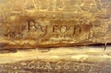
Byron's name carved into temple of Poseidon
The inscribed name of George Lord Byron, carved into the base of one of the columns of the Temple of Poseidon, possibly dates from his first visit to Greece, on his Grand Tour of Europe before he acquired fame. Byron spent several months in 1810–11 in Athens, including two documented visits to Sounion. There is, however, no direct evidence that the inscription was made by Byron himself. Byron mentions Sounion in his poem Isles of Greece:
-
- Place me on Sunium's marbled steep,
- Where nothing, save the waves and I,
- May hear our mutual murmurs sweep...[23]
Modern development
_(3734132499).jpg)
Sounion beach and Aegeon Beach hotel, seen from Cape Sounion (July 2009 photograph).
Lavreotiki municipality was established in 1890 under the name of Sounio, but renamed to Lavreotiki in 1891. Cape Sounion itself is located between the villages of Kato Sounio and Legena.
The Sounio national park (Εθνικός Δρυμός τού Σουνίου) was established in 1974 with a core area of 750 hectares.
Forming the southeastern endpoint of the Athens Riviera, Sounio is now an upscale summer home location for Athenians. Construction of villas across the bay northwest of Cape Sounio flourished in the 1960s to 1970s. The Grecotel Cape Sounio luxury resort was built in 1973.[26]
The project Arrangement of the Archaeological Site of Sounion (2011–2013) was co-financed by the Greek Ministry of Culture and Sports and the European Union (ERDF).
Monday, June 25, 2018
Cherokee Fire Ceremony , Where? Toronto Ontario When? 2016

A fire ceremony is a Native American practice that is usually performed every full moon. You do not have to wait for a full moon in order to do a fire ceremony. Fire Ceremonies are wonderful during a New Moon, when you want to introduce newness into your Life. This Native American ritual is easy, simple and an awe-inspiring event.
You can do a fire ceremony yourself during the New Moon (probably every other month) or with friends in the backyard where you dug a large pit in the ground in order to build a safe fire. You can use a large clay pot, a campfire, a bonfire or an old barbecue grill.
Here is an extras from the Native American Website listed in the link section:
HOW IS A FIRE CEREMONY PERFORMED?
Each of us bring something to burn that we would like to rid the emotions associated with our past (on the Full Moon) or a prayer request of something new (during the New Moon), that will burn, turn to smoke and release into the ethers.This allows the past energy to move along to its highest spiritual progression path and the new prayer request to move along to its highest spiritual progression path.
We may bring pictures, drawings, or intentions written on a piece of paper for the past or the newness.
For the past, after we have burned and released the emotions associated with it, then we have something prepared that is written down on a clean sheet of paper. This would be something new that we would like to call forth from God. For the newness, the prayer request is then burned and released into the ethers thereby replacing the past emotions with new ones.
We form a circle around the fire and one by one we call in support from Divine Sources that give us peace. E.g. - God, Jesus, Creator, the Blessed Virgin Mother, Spirit, the Universe, the Archangels, the Saints that we may feel closest to, Guardian Angels, etc.
We start with a prayer, and end with a prayer that is coupled with thanksgiving that our prayers and intentions have already been answered.
Keep in mind, no one is obligated to speak during a Fire Ceremony. Anyone can participate without stating what they are releasing or calling forth.
After we have called in our Divine Source we place into the fire our pictures, drawings and intended release of the emotions associated with the past. Once these things have burned to smoke and ash, we then place into the fire what we have written on clean sheet of paper. This would be what we desire to replace those old energies with and call in new.
The things we address from our past or call into our future can be shared with the group or kept to ourselves as we go through the Fire Ceremony.
In strict Native American custom - the burning of sage, sweetgrass or tobacco is burned along with the past, which is given as an offering. When the smoke rises up into the ethers and is carried away to God there should be a quiet or meditative break in order to embrace a new awareness of transformation in your life. It is also symbolic that you can offer up a bit of food you wanted and only ate half of so that you could offer the other half in thanks.
THE VALUE OF IMAGERY
Do not minimize the value of imagery in Native American ceremony. The Spirit of God is real. This is a way of demonstrating our gratefulness and thanksgiving to God. When we pray to our Source and Supply who is God; He can, will and does affect our lives. So honoring Him and showing Him respect is part of this ceremony.After your fire gets going, each person may contribute to the prayer and then the items are offered to the fire. Tell God and all the Divine Spirits that you have called forth that you offer these things in thanksgiving. Meditate and feel the presence of God all around you. Singing praise, playing peaceful music either through tapes or instruments may also be used.
Every Divine Source you called in is present, so give thanks and believe you have already received.
Links
http://www.drstandley.com/nativeamerican_fire.shtml
https://photos.app.goo.gl/9hmiNusLNcHZZKUj9
Wednesday, June 20, 2018
Friday, June 15, 2018
Thursday, June 14, 2018
Karnak Temple Egypt
Karnak Temple is actually a vast temple city, with many
of its structures dating back 4,000 years. It is today the largest
remaining religious site of the ancient world, and it is visited by
thousands of tourists every year.
Seeing this place makes you think/ question if at any time in the past the giants lived on the Earth.

Cult temple dedicated to Amun, Mut and Khonsu. The largest religious building ever constructed.
The temple of Karnak was known as Ipet-isu—or “most select of places”—by the ancient Egyptians. It is a city of temples built over 2,000 years and dedicated to the Theban triad of Amun, Mut, and Khonsu. This derelict place is still capable of overshadowing many wonders of the modern world and in its day must have been awe-inspiring.
For the Egyptian population, this could only have been the place of the gods. It is the largest religious building ever made, covering about 200 acres (1.5 km by 0.8 km), and was a place of pilgrimage for nearly 2,000 years.
The area of the sacred enclosure of Amun alone is sixty-one acres and could hold ten average European cathedrals. The great temple at the heart of Karnak is so big that St Peter’s, Milan, and Notre Dame Cathedrals would fit within its walls.
The Hypostyle hall, at 54,000 square feet (16,459 meters) and featuring 134 columns, is still the largest room of any religious building in the world. In addition to the main sanctuary there are several smaller temples and a vast sacred lake – 423 feet by 252 feet (129 by 77 meters).
The sacred barges of the Theban Triad once floated on the lake during the annual Opet festival. The lake was surrounded by storerooms and living quarters for the priests, along with an aviary for aquatic birds.
The Egyptians believed that towards the end of annual agricultural cycle the gods and the earth became exhausted and required a fresh input of energy from the chaotic energy of the cosmos.
To accomplish this magical regeneration the Opet festival was held yearly at Karnak and Luxor. It lasted for twenty-seven days and was also a celebration of the link between pharaoh and the god Amun. The procession began at Karnak and ended at Luxor Temple, one and a half miles (2.4 kilometres) to the south.
The statue of the god Amun was bathed with holy water, dressed in fine linen, and adorned in gold and silver jewellery. The priests then placed the god in a shrine and onto the ceremonial barque supported by poles for carrying. Pharaoh emerged from the temple, his priests carrying the barque on their shoulders, and together they moved into the crowded streets.
A troop of Nubian soldiers serving as guards beat their drums, and musicians accompanied the priests in song as incense filled the air.
At Luxor, (right) Pharaoh and his priests entered the temple and ceremonies were performed to regenerate Amun, recreate the cosmos and transfer Amun’s power to Pharaoh. When he finally emerged from the temple sanctuary, the vast crowds cheered him and celebrated the guaranteed fertility of the earth and the expectation of abundant harvests.
During the festival the people were given over 11000 loaves of bread and more than 385 jars of beer, and some were allowed into the temple to ask questions of the god. The priests spoke the answers through a concealed window high up in the wall, or from inside hollow statues.
Excavations in the 20th century pushed the history of the site back to the Gerzean period (c. 3400–c. 3100 bce), when a small settlement was founded on the wide eastern bank of the Nile floodplain. Karnak contains the northern group of the Theban city temples, called in ancient times Ipet-Isut, “Chosen of Places.”
The ruins cover a considerable area and are still impressive, though nothing remains of the houses, palaces, and gardens that must have surrounded the temple precinct in ancient times. The most northerly temple is the Temple of Mont, the war god, of which little now remains but the foundations.
The southern temple, which has a horseshoe-shaped sacred lake, was devoted to the goddess Mut, wife of Amon; this also is much ruined. Both temples were built during the reign of Amenhotep III (1390–53), whose architect was commemorated by statues in the Temple of Mut.
Between these two precincts lay the largest temple complex in Egypt, and one of the largest in the world, the great metropolitan temple of the state god, Amon-Re. The complex was added to and altered at many periods and, in consequence, lacks a systematic plan.
It has been called a great historical document in stone: in it are reflected the fluctuating fortunes of the Egyptian empire. There are no fewer than 10 pylons, separated by courts and halls and nowadays numbered for convenience, number one being the latest addition.
Pylons one through six form the main east-west axis leading toward the Nile. The seventh and eighth pylons were erected in the 15th century bce by Thutmose III and Queen Hatshepsut, respectively, and the ninth and tenth during Horemheb’s reign (1319–1292). These pylons formed a series of processional gateways at right angles to the main axis, linking the temple with that of Mut to the south and, farther, by way of the avenue of sphinxes, with the temple at Luxor 2 miles (3 km) away.
The most striking feature of the temple at Karnak is the hypostyle hall, which occupies the space between the third and second pylons. The area of this vast hall, one of the wonders of antiquity, is about 54,000 square feet (5,000 square metres). It was decorated by Seti I (reigned 1290–79) and Ramses II (reigned 1279–13), to whom much of the construction must be due.
Twelve enormous columns, nearly 80 feet (24 metres) high, supported the roofing slabs of the central nave above the level of the rest so that light and air could enter through a clerestory. Seven lateral aisles on either side brought the number of pillars to 134. Historical reliefs on the outer walls show the victories of Seti in Palestine and Ramses II defeating the Hittites at the Battle of Kadesh.
Ramses III (reigned 1187–56) built a small temple to Amon outside the Ramesside pylon across from a triple shrine erected by Seti II (reigned 1204–1198). The Bubastite Gate at the southeast corner of this court commemorates the victories won by Sheshonk I (reigned 945–924), the biblical Shishak, in Palestine.
The Kushite (Nubian) pharaoh Taharqa (reigned 690–664) erected a tall colonnade, of which one pillar still stands. The smaller monuments were subsequently enclosed by the addition of a vast court, probably begun during the Late Period (664–332 bce), fronted by the massive first pylon, an ambitious project that was never completed. Beyond it an avenue of sphinxes—set in place largely by Amenhotep III and usurped by Ramses II—leads to the quayside.
Within the enclosure of the Great Temple of Amon are included a number of other notable small shrines and temples. A temple to Ptah, in the north side of the enclosure, was built by Hatshepsut and Thutmose III and added to by the Ptolemies, who also embellished the Great Temple of Amon by the addition of granite shrines and gateways.
To the south, Ramses III dedicated a temple to Khons, the moon god, which merits attention. A small late temple to Opet, the hippopotamus goddess, adjoins it.
Karnak Temple – A Long Legacy
Perhaps the most famous element of the Karnak Temple is the Hypostyle Hall, which was begun in the 18th Dynasty and finished in the 19th Dynasty, composed of 134 papyrus-shaped pillars, many 21 meters high and 3 meters in diameter, decorated with reliefs and paint still visible today.
Queen Hatshepsut, daughter of Thutmose I and wife of Thutmose II, usurped the throne for 22 years and was possibly the “daughter of Pharaoh” that drew Moses out of the Nile and adopted him (Exodus 2:5–10). At Karnak, she constructed Egypt’s tallest obelisks 29.5 meters, one which can still be seen today, along with her cartouche on it.
Thutmose III (ca. 1504–1450 BC), who according to biblical chronology reigned just before the Exodus and 40 years of wilderness wandering and suggested by some to be a Pharaoh of the oppression or Pharaoh of the Exodus, had a topographical relief constructed on the sixth and seventh pylons that listed cities in the Levant that he conquered. Many of these cities are also recorded in the Old Testament, and in the proper order, including a set from Numbers 33:45-50. Inscribed on the wall are locations as part of a topographical list containing 119 place-names in Canaan, Transjordan, Lebanon and Syria. The Egyptian route from the Arabah to the Plains of Moab lists four locations: Iyyin, Dibon, Abel, and the Jordan River. Numbers 33 lists six locations they camp at: Iyyim, Dibon-gad, Almon-diblathaim, Mt. Nebo, Abel-shittim, and the Jordan River. By comparing the two lists, one can see the route taken by the Israelites through Transjordan matches correctly with the Egyptian topographical list. Thus, the travel account in Numbers 33 is not only accurate, but in accordance with data from around 1450 BC, just over 40 years before the Israelites made the journey on this route.
Karnak Temple – The Way of the Land of the Philistines
The Canaan campaign reliefs of Seti I (ca. 1294-1274 BC) on the walls of the Karnak Temple depict the “Way of the Land of the Philistines” that the Israelites avoided in their Exodus (Exodus 13:17), as it was said to be a place where they would encounter war. On this relief at the Karnak Temple complex, a map of the Horus way shows 11 forts and a north-south reed lined waterway crossing called “ta denit” (the dividing waters).
Combine this map with Papyrus Anastasi I, and 23 Egyptian fortifications are present along the highway from Tjaru at the border of Egypt to Rafa at the border of Canaan. The site of Tjaru has been identified as a border fortress and town near modern Qantara, northeast of the Ballah Lake.
Inscriptions show its use by 18th and 19th Dynasty Pharaohs, specifically Thutmose II, Seti I, and Ramses II. Thus, the Israelites avoided the easy path along the coast as God had commanded because it was heavily guarded by Egyptian troops, and recent archaeological research has demonstrated this “Way of the land of the Philistines,” also known as the “Way of Horus,” to be guarded by Egyptian border fortresses.
Karnak Temple – Pharaoh Merenptah (Merneptah)
The Pharaoh Merenptah (ca. 1213-1203 BC) also commissioned a relief at the Karnak Temple, one which is thought to correspond to the Merenptah Stele (Merneptah Stele) mentioning Israel found in his mortuary temple near Thebes on the west bank of the Nile and now housed in the Egyptian Museum in Cairo.
The relief is especially important to Biblical history because it may contain the earliest artistic representation of Israelites. The alleged Israelites in the relief are dressed more like Canaanites, whose culture they progressively adapted to during the Judges period when this relief was designed, instead of Shasu nomads like they were during the Exodus and wandering period.
Karnak Temple – Pharaoh Shishak (Shoshenq)
Finally, the topographical list of Pharaoh Shishak I (ca. 943-922 BC) commemorated his conquests in the kingdoms of Israel and Judah, mentioned in 1 Kings 14:25 and 2 Chronicles 12:2-4. On the wall of the Bubastite Portal at the Temple of Amun in Karnak, a long list of place names is recorded in relation to military conquest.
Part of it records the military campaign of Shoshenq I (Shishak 1) against Canaan and the Negev, supposedly naming captured cities in this conquest or tribute expedition of Shoshenq I. According to the Shishak Relief, both Israelite and Judean cities were involved.
This campaign was probably against Jeroboam of Israel and Rehoboam of Judah, as indicated by 1 Kings and 2 Chronicles, although neither name is found in the Egyptian inscriptions, but this is expected as the list does not contain personal names. At this point in the history of the Divided Kingdom, the Hebrew writers are not very concerned with the Northern Kingdom, and there is no information about Shoshenq I’s attacks in the north.


Links
https://www.youtube.com/watch?v=7_GWoT0jtQw
Subscribe to:
Posts (Atom)