https://youtu.be/058wdDNy7kw
Tuesday, July 9, 2019
Wednesday, July 3, 2019
History, Native Americans and Algonquin Park
The Archaeological evidence puts the earliest ancestors of the Algonquin pep;e in the landscape now known as Ottawa River watershed spanning both Ontario and Quebec at least 12,000 years ago tough the oral tradition state that they have been here sine time immemorial.
The Algonquin landscape is one of sacred rugged beauty.The most effective methods of transportation was by water via the birch bark canoe. During the winter they travelled with snowshoes specifically adapted for the landscape.
Algonquins are people of the rivers.The Ottawa river known to Algonquin people as Kitchisippi ( Big River) is the livelihood and main artery.
The waterways of this river provide endless travel routes through territory to hunt fish gather plants camp and trade. The rivers were the root of survival of Algonquin nut they also have been the reason for the near extinction of the nation.
The first encounter between an Algonquin and a European was in 1613 with Samuel Champlain at Allumette Island. Champlain had written to France that Algonquin territory was a sort of Paradise offering unending supply of "resources". aquatic species, mammals and timber.
Before that in 1530 Chartier initiated the earliest European Indigenous fur trade along the St Lawrence River supporting a infamous fashion statement the beaver felt hat. These hats served as a status symbol for wealth and status for French and English until 1700.
As a demand for fur the beaver population quickly became threatened along the St Lawrence River.
By 1640 additional pressures encroached Anishinaabeg territories, with the teritories. Beaver Wars also known as Iroquois Wars had begun. Lasting between 1640-1701 the Beaver Wars were brutal ruthless and bloody wars fought by tribes of the Iroquois Confederacy against the French Fur Traders and their allies including the Algonquin.
As a result of these battles the Iroquois decimated the population of Anishinaabeg people including the Algonquins.
With the knowledge that Anishinaabeg territory, including Algonquin territory was bontiful in mammals, fish land and timber during the Iroquois War, the Ottawa velley saw a great influx of settlers in search of resources and life in the new World, leading to further displacement of Algonquins throughout the traditional familial hunting grounds.
in 1759 the Algonquin and Nipissing peole came under the colonial government's Indian Affairs Department and the Royal Proclamation of 1763 gave official recognition of the territorial rights of First Nation people, including Algonquin, Nipissing and Ojibwe.
By 1772 less than 10 years after the Royal Proclamation the Algonquin and Nipissing people were forced to submit their first of many formal claims to their traditional Territory, requesting that their traditional Territory to remain preserved enough to support their families. This was the first petition to the Crown to defend their territory.
From 1700 to mid 1800 Algonquins could still find refuge in their territories and carry subsistence lifestyle, in places such as present day Algonquin Park.
Algonquin Nation is still alive today as 2019 is broken into many familial territories that are divided by river and the name of these rivers are reminiscent of the traditional people of that particular river.
One of the main tributaries of Ottawa river is the Madawaska. This river begins at Source Lake in Algonquin Park and over 230 kn and drainage meets Ottawa river.
Madawaska River is home to Madaoueskarini people still alive today that mainstream history and school fail to talk about.
When it was first "discovered" one of the most notable elements of Madawaska headwaters area (present day Algonquin Park) was the amount of huge Pine trees. The first timber licence in the Madawaska headwaters area was issued in 1836. It was believed that there was enough timber to last for 700 years. Within 70 years they were gone.
in 1863 eight chiefs an over 250 individual Algonquins and Nipissing petitioned the Governor General of Canada for a specific tract of land to be set aside for 400 Algonquin families.
By 1866 Indian Affairs had decided that a southeast quarter of Township of Lawrence now southern portion of Algonquin Park to be set apart. However these Algonquins people did not have any right to merchantable timber on the land, nor could they interrupt those parties who hold timber licences.
in 1867 once Upper Canada became the province of Ontario, Pon Somogeneche,High Chief of the Algonquin and Nissiping had not yet received any recognition of the promised reserved land.
In 1893 Agonquin National Park was created as this was the first Provincial Park in Ontario.
To this day lumber is still harvested.
Upon Somogoneche asking once again for reserve lands near the border of Algonquin Park they were refused.
Soon birders would be drawn around Algonquin National Park , rules and regulations would be put in place and traditional ways of Native Americans were forcibly changed without any consultation or respect to the thousands of years of presence in this land. People were evicted from their homes the community was broken, some were moved in Indian Reserves small pieces of land. Those that refused to move became Non Status Algonquins.
Slave labour was used for logging with people living in camps similar with Nazi Concentration camps from later date Living 40 worker is a extremely small cabin as specified and demonstrated in the Algonquin Park Museum.
The sad part is that this public park has nothing public about is is a space where wood is cut every 20 -40 years. on each piece of land. There are not old trees in the park any more.
The tourists pay $18 parking per day a price of parking in a large city such as Toronto.
Somebody still makes money from the ownership of the land and wood in this Public Park. And That is wrong. The land should be left alone if is a natural reserve. Private corporations should live this sacred land alone.
There are not old trees in the park any more. Name such as sustainable harvesting are just a justification for environmental destruction. They should stop.
Bibliography
Algonquin Life magazine."A Brief history of Madaueskarini Algonquin People" by Christine Luckasavich


 Megalits, possible remains of an ancient civilization .


 Art in the Park.


 There are no more large trees like this one alive in the Park.
 Possible ancient ruins.

 Nazi style concentration camps so few can make a fortune.

 More rectangular shaped large blocks having 90 degree angles.Machu Picchu style

The Algonquin landscape is one of sacred rugged beauty.The most effective methods of transportation was by water via the birch bark canoe. During the winter they travelled with snowshoes specifically adapted for the landscape.
Algonquins are people of the rivers.The Ottawa river known to Algonquin people as Kitchisippi ( Big River) is the livelihood and main artery.
The waterways of this river provide endless travel routes through territory to hunt fish gather plants camp and trade. The rivers were the root of survival of Algonquin nut they also have been the reason for the near extinction of the nation.
The first encounter between an Algonquin and a European was in 1613 with Samuel Champlain at Allumette Island. Champlain had written to France that Algonquin territory was a sort of Paradise offering unending supply of "resources". aquatic species, mammals and timber.
Before that in 1530 Chartier initiated the earliest European Indigenous fur trade along the St Lawrence River supporting a infamous fashion statement the beaver felt hat. These hats served as a status symbol for wealth and status for French and English until 1700.
As a demand for fur the beaver population quickly became threatened along the St Lawrence River.
By 1640 additional pressures encroached Anishinaabeg territories, with the teritories. Beaver Wars also known as Iroquois Wars had begun. Lasting between 1640-1701 the Beaver Wars were brutal ruthless and bloody wars fought by tribes of the Iroquois Confederacy against the French Fur Traders and their allies including the Algonquin.
As a result of these battles the Iroquois decimated the population of Anishinaabeg people including the Algonquins.
With the knowledge that Anishinaabeg territory, including Algonquin territory was bontiful in mammals, fish land and timber during the Iroquois War, the Ottawa velley saw a great influx of settlers in search of resources and life in the new World, leading to further displacement of Algonquins throughout the traditional familial hunting grounds.
in 1759 the Algonquin and Nipissing peole came under the colonial government's Indian Affairs Department and the Royal Proclamation of 1763 gave official recognition of the territorial rights of First Nation people, including Algonquin, Nipissing and Ojibwe.
By 1772 less than 10 years after the Royal Proclamation the Algonquin and Nipissing people were forced to submit their first of many formal claims to their traditional Territory, requesting that their traditional Territory to remain preserved enough to support their families. This was the first petition to the Crown to defend their territory.
From 1700 to mid 1800 Algonquins could still find refuge in their territories and carry subsistence lifestyle, in places such as present day Algonquin Park.
Algonquin Nation is still alive today as 2019 is broken into many familial territories that are divided by river and the name of these rivers are reminiscent of the traditional people of that particular river.
One of the main tributaries of Ottawa river is the Madawaska. This river begins at Source Lake in Algonquin Park and over 230 kn and drainage meets Ottawa river.
Madawaska River is home to Madaoueskarini people still alive today that mainstream history and school fail to talk about.
When it was first "discovered" one of the most notable elements of Madawaska headwaters area (present day Algonquin Park) was the amount of huge Pine trees. The first timber licence in the Madawaska headwaters area was issued in 1836. It was believed that there was enough timber to last for 700 years. Within 70 years they were gone.
in 1863 eight chiefs an over 250 individual Algonquins and Nipissing petitioned the Governor General of Canada for a specific tract of land to be set aside for 400 Algonquin families.
By 1866 Indian Affairs had decided that a southeast quarter of Township of Lawrence now southern portion of Algonquin Park to be set apart. However these Algonquins people did not have any right to merchantable timber on the land, nor could they interrupt those parties who hold timber licences.
in 1867 once Upper Canada became the province of Ontario, Pon Somogeneche,High Chief of the Algonquin and Nissiping had not yet received any recognition of the promised reserved land.
In 1893 Agonquin National Park was created as this was the first Provincial Park in Ontario.
To this day lumber is still harvested.
Upon Somogoneche asking once again for reserve lands near the border of Algonquin Park they were refused.
Soon birders would be drawn around Algonquin National Park , rules and regulations would be put in place and traditional ways of Native Americans were forcibly changed without any consultation or respect to the thousands of years of presence in this land. People were evicted from their homes the community was broken, some were moved in Indian Reserves small pieces of land. Those that refused to move became Non Status Algonquins.
Slave labour was used for logging with people living in camps similar with Nazi Concentration camps from later date Living 40 worker is a extremely small cabin as specified and demonstrated in the Algonquin Park Museum.
The sad part is that this public park has nothing public about is is a space where wood is cut every 20 -40 years. on each piece of land. There are not old trees in the park any more.
The tourists pay $18 parking per day a price of parking in a large city such as Toronto.
Somebody still makes money from the ownership of the land and wood in this Public Park. And That is wrong. The land should be left alone if is a natural reserve. Private corporations should live this sacred land alone.
There are not old trees in the park any more. Name such as sustainable harvesting are just a justification for environmental destruction. They should stop.
Bibliography
Algonquin Life magazine."A Brief history of Madaueskarini Algonquin People" by Christine Luckasavich


Wednesday, June 26, 2019
Monday, June 24, 2019
Monday, June 17, 2019
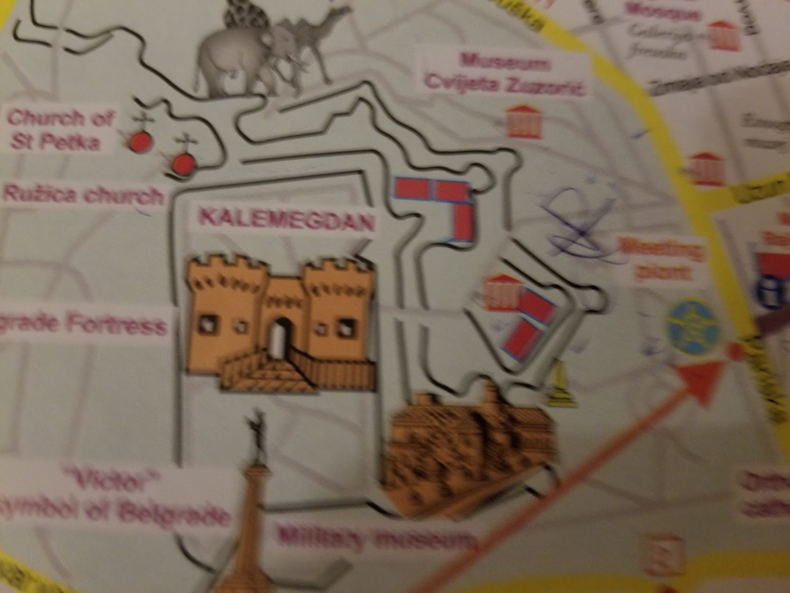
Star Fort, Belgrade Fortress Serbia
Belgrade Fortress, consists of the old citadel and
Kalemegdan Park on the confluence of the River Sava and Danube, in an
urban area of modern Belgrade, the capital of Serbia. It is located in
Belgrade's municipality of Stari Grad
Battles/wars: 1440, 1456, 1521, 1688, 1690, 1717, 1739, 1789, 1806
Owner: Belgrade
Built: 279 BC
Area: 66 ha (160 acres)
Materials: Stone
Questions: how many people really built this frotress?
What kind of system they had to produce such an amount of material for building this fortress? Who designed it?
How they verified that the form of a star is respected . The form can be seen only from above and the fortress is not built on flat land is built on a cliff.
The material that was built was stone first and brick after. How many brick factories have been employed for the building of this fortress? How about the previous stone fortress? What kind of machined they had to move such an amount of material?
How many people were really employed for the building of the fortress?
How large were the people who built it? Check the doors how large they are.
Was this place mud flooded? There is 1 m at least cover with soil from the initial base of the walls. It was in top of a mountain so the mud does not come there easily.
The first mention of the city is when it was founded in the
3rd century BC as "Singidunum" by the Celtic tribe of Scordisci, who
had defeated Thracian and Dacian tribes that previously lived in and
around the fort. The city-fortress was later conquered by the Romans,
was known as Singidunum and became a part of "the military frontier",
where the Roman Empire bordered "barbarian Central Europe".
Kalemegdan park and Belgrade fortress
Why visit: History of Belgrade (Ancient, Medieval,
Turkish), Archaeology, Top landmarks and attractions, Great panoramic
views, Culture, Walking, Relaxation, Sports, People, Animals, Cafes,
Souvenirs…
Also known as: Kališ, Tvrđava, Citadel, Belgrade fortress, Belgrade castle
Kalemegdan is Belgrade’s central park and fortress complex
lying on a hill overlooking the Sava and Danube confluence, on the
eastern side of the river Sava.
This has been the sight of the ancient
Roman city of Singidunum, the medieval and Turkish era Belgrade and was
converted into a park in the mid 19th century. It is home to several
galleries and museums, restaurants, sports courts, and the Belgrade Zoo.
Roman Well
Many legends surround the Roman Well, one of Belgrade’s
most mysterious attractions, built at the beginning of the 18th century,
during the baroque reconstruction of the fortress. It is believed that
it was constructed upon a much older one, two thousand year old Roman
well, that served to provide water to the Roman castrum in case of
siege.
Alfred Hitchcock visited the well in 1964 and said that an environment like that is always a treat for him.
The well is 51m deep (it’s bottom lies below the bottom of
the nearby Sava river), with 3m in diameter and two spiral staircases
that connect at the depth of about 35 meters forming a DNA-like shape.
The water in the well is incredibly clean, and is home to
an endemic species of tiny crab that lives only there. The source of the
water still hasn’t been clearly determined.
Due to high humidity levels, stalactites (cave decorations) have formed around the well.
Belgrade Fortress, consists of the old citadel (Upper and Lower Town)
and Kalemegdan Park (Large and Little Kalemegdan) on the confluence
of the River Sava and Danube, in an urban area of modern Belgrade, the
capital of Serbia. It is located in Belgrade's municipality of Stari
Grad. Belgrade Fortress was declared a Monument of Culture of
Exceptional Importance in 1979, and is protected by the Republic of
Serbia.
It is the most visited tourist attraction in Belgrade,
with Skadarlija being the second.Since the admission is free, it is
estimated that the total number of visitors (foreign, domestic, citizens
of Belgrade) is over 2 million yearly.
Belgrade Fortress
Beogradska tvrđava
Stari Grad, Belgrade in Serbia
Kalemegdan Park and the Fortress
Coordinates 44°49′24″N020°27′01″E TypeFortress
Area 66 ha (160
acres)
Site information
Owner City of Belgrade histor Built279 BC Built by Justinian I (reconstructed in 535)
Stefan Lazarević(reconstructed in 1403)
Nicolas Doxat de Démoret (reconstructed 1723-36)MaterialsStoneBattles/wars1440, 1456, 1521, 1688, 1690, 1717, 1739, 1789, 1806.
Stefan Lazarević(reconstructed in 1403)
Nicolas Doxat de Démoret (reconstructed 1723-36)MaterialsStoneBattles/wars1440, 1456, 1521, 1688, 1690, 1717, 1739, 1789, 1806.
Location
Old Name -Singidunum
Belgrade Fortress is the core and the oldest section of the
urban area of Belgrade. For centuries the city population was
concentrated only within the walls of the fortress, and thus the history
of the fortress, until most recent times, equals the history of
Belgrade itself
The first mention
of the city is when it was founded in the 3rd century BC as "Singidunum"
by the Celtic tribe of Scordisci, who had defeated Thracian and Dacian
tribes that previously lived in and around the fort.
The city-fortress
was later conquered by the Romans, was known as Singidunum and became a
part of "the military frontier", where the Roman Empire bordered
"barbarian Central Europe".
Singidunum was defended by the Roman legion
IV Flaviae, which built a fortified camp on a hill at the confluence of
the Danube and the Sava rivers. In the period between AD 378 and 441 the
Roman camp was repeatedly destroyed in the invasions by the Goths and
the Huns.
Legend says that Attila's grave lies at the confluence of the
Sava and the Danube (under the fortress).
In 476 Belgrade again became
the borderline between the empires: the Western Roman Empire and Eastern
Roman Empire (Byzantine Empire), and the Slav-Avar State in the north.
The Celtic fortification was a primitive one, located on
top of Terazije ridge, above the confluence of the Sava into the Danube,
where the fortress still stands today. Celts also lived in small, open
and fortified settlements around the fort, called opidums.
Since it
is not known for sure where the Celtic fort was, some historians suggest
that it was rather close to the necropolises in Karaburma and Rospi
Ćuprija. Celtic settlements belonged to the La Tène culture.
The original military camp was probably occupied by the
soldiers from the Legio VIII Augusta from 46 AD to 69 AD. Early
Singidunum reached its height with the arrival of Legio IV Flavia
Felix which was transferred to the city in 86 AD and remained there
until the mid 5th century.
The presence of Legio IV prompted the
construction of a square-shaped castrum (fort), which occupied Upper
Town of today's fortress.
Construction began at the turn of the 2st
century AD as since the early 100s, Legio IV Flavia Felix became
permanently stationed in Singidunum.
At first, the fortress was set up
as earthen bulwarks and wooden palisades, but soon after, it was
fortified with stone as the first stone fort in Belgrade's history. The
remains can be seen today near the northeastern corner of the acropolis.
The legion also constructed a pontoon bridge over the Sava, connecting
Singidunum with Taurunum.
Rectangular castrum covered what is today the Upper Town
and the Kalemegdan Park. The castrum had tall walls, built from the
white Tašmajdan limestone and spread over the area of 16 ha (40 acres)
to 20 ha (49 acres), being shaped as an irregular rectangle
(approximately 570 by 330 m (1,870 by 1,080 ft)).
Despot Stefan Tower
Stambol Gate.
Gate of Charles VI.
Middle Ages
The Byzantine Emperor Justinian I rebuilt the fortress
around 535.[8] In the following centuries the fortress suffered
continuous destruction under the Avar sieges. The Slavs (Serbs) and
Avars had their "state union" north of Belgrade with the Serbs and other
Slavic tribes finally settling in the Belgrade area as well as the
regions west and south of Belgrade in the beginning of the 7th century.
The name Belgrade (or Beograd in Serbian), which, not just in Serbian
but in most Slavic languages, means a "white town" or a "white
fortress", was first mentioned in AD 878 by Bulgarians.
The fortress
kept changing its masters: Bulgaria during three centuries, and then the
Byzantines and then again Bulgarians. The fortress remained a Byzantine
stronghold until the 12th century when it fell in the hands of the
newly emerging Serbian state.
It became a border city of the Serbian
Kingdom, later Empire with Hungary. The Hungarian king Béla I gave the
fortress to Serbia in the 11th century as a wedding gift (his son
married the Serbian princess Jelena), but it remained effectively part
of Hungary, except for the period 1282–1319.
After the Serbian state
collapsed after the Battle of Kosovo, in 1402 Belgrade was chosen as the
capital of Despot Stefan Lazarević. Major work was done to the ramparts
which were encircling a big thriving town. The lower town at the banks
of the Danube was the main urban center with a new built Orthodox
cathedral. The upper town with its castle was defending the city from
inland.
Belgrade remained in Serbian hands for almost a century. After
the Despot's death in 1427 it had to be returned to Hungary. An attempt
by Sultan Mehmed II to conquer the fortress was prevented by Janos
Hunyadi in 1456 (Siege of Belgrade), saving Hungary from Ottoman
dominion for 70 years.
Early Modern
In 1521, 132 years after the Battle of Kosovo, the
fortress, like most parts of the Serbian state, was conquered by
the Turks and remained (with short periods of the Austrian and Serbian
occupation), under the rule of the Ottoman Empire until the year 1867,
when the Turks withdrew from Belgrade and Serbia. During the short
period of Austrian rule (1718–1738), the fortress was largely rebuilt
and modernized. It witnessed the Great Serbian Migration in the 17th
century and two Serbian Uprisings in the 19th century, during
the Turkish Period.
During the Austrian occupation of northern Serbia 1717-39,
several hospitals were established in Belgrade. The City hospital of
Saint John was built within the fortress walls, but its exact location
is not known. Emperor Charles VI signed the Belgrade City Statute in
1724 ("Proclamation on organizing German Belgrade"), which mentions city
hospital, city pharmacy, medics and midwives. The German municipality
had low incomes so it had to ask the state for help and beneficence. The
hospital is mentioned in the 1728 Census.
It was a hospital already in
1719, later becoming the residence of Thomas Berger, the head of the
hospital. After his death, his daughter continued to reside in the
building. The hospital (Stattspital) was moved to another location, into
the newly constructed building in 1724. A small church was built next
to it. This new hospital was quite small, with only 2 rooms, a kitchen
and a basement, so it way not be the same city hospital.[13]
Lazaret or a quarantine hospital is not mentioned in the
documents, but it is safe to presume that it had to be formed during the
viral outbreaks, as was usual in the time. The procedure in case of
outbreaks was probably analog to the existing procedure in Buda, the
capital of Hungary.
Today unidentified disease ravaged Belgrade in 1730.
Viral epidemic killed a lot of people. During the course of only two
weeks, just the Jesuits buried 220 people and themselves lost 3
missionaries. The extremely massive plague outbreak hit the city in
October 1738. As Austrian army retreated in front of the advancing
Turks, numerous civilians fled to the fortress, many of them being
contagious.
Having so many people in a cramped space, the triage was not
possible so the plague spread quickly. There are reports of the dead
lying in the streets for days as there was no one to bury them. Austrian
garrison was decimated and the corpses of the soldiers who died of
plague were burned with their personal properties.
After Austria lost the Austro-Turkish War of 1737–1739, the
northern Serbia, including Belgrade, was returned to the Turks. One of
the provisions of the 1739 Treaty of Belgradestated that Austria had to
demolish all the fortifications and military and civilian building it
has constructed during the occupation. Many Baroque buildings were
demolished within the fortress. However, Austria didn't demolish the
buildings outside of the fortress walls. That way, the House at 10 Cara
Dušana Street, built from 1724 to 1727, in the neighborhood of Dorćol
survived, being today the oldest house in Belgrade.
Modern
While it was inhabited, the fortress formed one of the
quarters in the administrative division of Belgrade. It was called Grad,
and translated in the foreign languages as "fortress". According to the
censuses, it had a population of 2,219 in 1890, 2,281 in 1895, 2,777 in
1900, 2,396 in 1905 and 454 in 1910.
Kalemegdan was the location of the second airport in
Serbia, after one in the neighborhood of Banjica from 1910. A field in
the Donji Grad was adapted for planes in January 1911. It was situated
along the bank of the Sava river, from the old Turkish bath (modern
Planetarium) to the mouth of the Sava into the Danube.
One of the flight
pioneers, Edvard Rusjan, died in an airplane crash after taking off
from this field on 9 January 1911. Today, the area is used by the
parachutists and paragliders and as the location of the air shows for
sports and ultra-light aviation.
In 1928, building company "Šumadija" proposed the
construction of the cable car, which they called "air tram".
The project
was planned to connect Zemun to Belgrade Fortress, via Great War
Island. The interval of the cabins was set at 2 minutes and the entire
route was supposed to last 5 minutes. The project was never realized,
bud the idea of the cable car was revived in the 21st century.
The fortress suffered further damage during the First and
the Second World Wars. After almost two millennia of continuous sieges,
battles and conquests, the fortress is today known as the Belgrade
Fortress.
The present name of Kalemegdan Park derives from
two Turkish words, kale (fortress) and meydan(battlefield) (literally,
"battlefield fortress").
After World War II, before skiing facilities were built on
the mountains further from Belgrade, the slopes of Kalemegdan (so as
of Banovo Brdo, Košutnjak and Avala), were used by Belgraders for
skiing
Archaeology
Jakšić's Tower
On 29 February 1952 city adopted the "Decision on
protection, adaptation and maintenance of the people's park of
Kalemegdan" which set the borders of the protected areas as the rivers
of Danube and Sava and the streets of Tadeuša Košćuškogand Pariska.
In
1962, Belgrade's Institute for the cultural monuments protection
expanded the zone to several blocks across the streets. Detailed plan on
Kalemegdan from 1965 provided that, despite the immense archaeological
value that lies beneath the fortress ground, basically only what was
discovered by that time can be explored, restored or protected.
That
caused the problem both for the expansion of the park but even more for
the further exploration of the fortress' underground. Best example is
the Lower Town where neither the park fully developed nor the remains of
the former port, which was located there, are visible.
The area of the fortress is 66 ha (160 acres). By 2000,
only 5% of that area was archaeologically surveyed, and by 2010 that
number rose to 12% or 8 ha (20 acres).
Based on the findings so far, it
is estimated that during the rule of despot Stefan Lazarević in the
first half of the 15th century, when Belgrade became capital of Serbia,
the city within the fortress had 5,600 to 12,000 inhabitants.
Archaeological examinations were done on the next locations:
Gornji Grad in the inner fortress; surveyed 1948-2009;
found remains belong to the Prehistory, Antiquity, Middle Ages and
Turkish-Austrian period; waterfront rampart in Donji Grad; 1963-2010; Middle Ages and Turkish-Austrian period;
Kalemegdan Park; 1973-2010; Antiquity, Middle Ages and Turkish-Austrian period;
Belgrade Zoo; 1988; Antiquity, Middle Ages and Turkish-Austrian period;
The explored sections after 2000 include the access
downhill path to the Small Staircase in Kalemegdan Park, the bastion on
the Sava slope, the gates of King, Sava, Dark and Karađorđe, the
Great Ravelin.


Subscribe to:
Posts (Atom)